Maps, Myths & Mystery
Learning The Lie of The Land


Home...
High on a hill stood a lonely goat! Yodley-ee yodeley-ee yodeley -ee-oh! ... Jelly orbs of snail eggs... Scurrying in undergrowth... Wet leaves and nettles and hay fields and bluebells... Cliffs full of crystals, mushroom fairy rings... These are a few of my favourite things... Woods and coedwig and forests full of deafening... silence... pine needles... underfoot... Gwynt o'r ochor... The smell of damp earth and mossy peat... A long haired man who plays the flute and sends it's sounds drifting into the wind over the valley... Pitch black quarry caves, dripping with ancient waters... Dampness... Owain Glyndwrs jail underground... Secret passageways from his old fort... The hill covered in unexplained wooden crucifixes... The 'Mental hospital' who's residents roam about bewildered and suffering... The rushing, relentless river, like a snake of power weaving through our consciousnesses ...Whispers of dirty old men abusing children... Unsolved missing persons... Cow slashing... UFO crashes on the moors... Heroin addicts... 'Inbred freaks'... who might chase you in the dark if you're not 'careful'... Bright moons and endless stars... The Milky Way like Mother... Hercules Bombers... Thunderstorms and floods... Dead sheep tangled and rotting in barbed wire... Moles hung in dissolving rows from fences... Eels wrapping around tiny feet and foals dropping out of horses vaginas... all slimy on the floor... We walked all of the mountains... Real mountains... where you can die if you're not 'careful'... Icy streams that gush through moss covered rocks and rotten wood... Hands full of woodlice and mud... Rose petal potions and cow pat flinging... Wellies and nakedness... Sledging and swimming... Wild children in a wild land...
But what happens to the wild children in a tame world...where no one else can hear the language of the trees or the soul of the mountain?
Maps
I have held a long fascination with Maps, which can easily be traced to childhood and my Dad’s love of mountain walking.
Sunday afternoons in front of the crackling fire, OS Maps of the Snowdonian landscape, or the Berwyn Range spread about on the floor, as he relayed advice on how to survive If you were to get lost ‘out there’.
“Follow the streams downhill” he would say “and always check upstream for dead sheep before drinking the water”.
Maps held not only the promise of some kind of adventure, but also the sense of wisdom that comes with knowing where things are in relation to one another.
Growing up in North Wales, the OS maps with their useful data were merged with the topography of myth and legend, of historical events and legendary tales.
Places named after characters and happenings; routes which held ancient secrets; ruined castles; strange phenomenon; ghostly hauntings; and dragons lurking beyond dotted lines - converged with the geographical information, to create maps of the mind, maps full of stories and meanings, projected onto those ancient landscapes across time and space.
The imagined, the symbolic and the ‘real’ blended to create a landscape far greater than the physical one we explored on our long walks.
Symbols
I found it endlessly fascinating that such a wild, vast, chaotic, dangerous, mythical, beautiful and very much 3 dimensional world could be encoded in symbols onto a piece of flat paper.
That the lines varying in density signified a steepness that was tangible and imaginable.
That the routes and paths worn by our ancestors since prehistory, had shaped the ways we relate to, traverse and symbolise the land now.
It seemed such a great and comforting feat of human ingenuity and perseverance, that we had taken that wild, inhuman reality and brought safety and order to it through this magical language of dots, lines, numbers and symbols.
The cognitive challenge of imagining the landscape from looking at the paper, and the equally mind bending exercise of standing in the landscape and equating our position to the images on the map - left in me a profound sense that the world was not altogether how it appears on paper, yet somehow, it was reducible to some kind of reliable and recognisable pattern.
Vista
To stand on a peak or a viewpoint and get your bearings via a line of sight, from one landmark to another, brings a sense of order and safety to a chaotic and dangerous world.
To get a sense of one's position in relation to the compass points, to the sunset or sunrise, or to the direction in which the water flows, connects us with the greater patterns of the world in which we live.
It expands perception to a non-human scale - where the boundaries of self move outward to include mountains, rivers, oceans and the ineffability of the incomprehensible.
It allows us to perceive the enormity of a reality far beyond our human-centric concerns, where we are dwarfed and rendered irrelevant by natures expanse.
It brings us outside of ourselves and into a greater interconnectedness with the universe and it's vastness.
And it does us good to be reminded.
People have lived, traversed and gathered at these high points and special places marked out by nature since time immemorial. The landscape and how we have historically related to it's stories and happenings, has informed and shaped our very understanding of ourselves, our history and our place in the 'Grand Scheme' of Earth's existence.
Perceiving the world in this expanded way, where the map, the landscape and the self blur into one, brings a certain magic to life - a transcendence, which never ceases to amaze and inspire.
Lying on the living room floor looking down over the whole of Snowdonia, felt almost God-like.
Overseeing the magical domain from a birds eye, sky view, like an eagle flying high over the mountains and looking down at the tiny house below - where a tiny human was inside, looking at a map on the living room floor, brought a freedom of perspective that has always remained.
Patterns
On Moving to Bristol, with it’s steep hills and winding roads, I found myself in a totally new kind of map. A much denser one, with far more human intervention into the pattern than was familiar.
Looking out from the many viewpoints and high places helped to build a mind model of the city - but it seemed to be full of unexpected twists, turns, and confusing relationships between places.
It seemed as though the sheer weight of history had bent time and space into complex arrangements, which we were compelled to maintain with our routes and interactions.
So many people, events and happenings, crammed into such a small area, layered over and over by time and history, seemed to complexify the structure of the landscape.
Footsteps piled up on one another into intricately woven imprints, seemed to cause the very fabric of reality to gather and twist to form the arches of the cathedral, the steep alleyways and the medieval lanes.
It felt like wandering through the mind of a living, dreaming being - the city and all its gathered memories, speaks in the language of cobblestone and church bell, it sings songs from the docks and tells stories with it’s corners and drains.
Order
The urge to bring order to this chaos and to apply a pattern of understanding to this new environment intensified as I learned more about the fascinating geography and history of Bristol and the wider West Country landscape.
I saw patterns and traces of the past everywhere merged with modern development, and began to question the process involved in maintaining and building upon what had come before.
What factors influenced the placement of important buildings in the layout of the modern and ancient city?
Which events and people were deemed important enough to commemorate in street names and grand buildings?
What was intrinsically important about the sites chosen for these impressive cultural beacons?
What geographical factors lay at the heart of these placements?
Stripping away the layers of History reveals what lies beneath, and it is invariably some natural feature, such as a well, spring or confluence; a unique or symbolic quality of the landscape; a folk memory of strange, unexplainable or historic events, occurrences or visions; or some kind of acoustic anomaly - which lie at the heart of the place.
Searching to find the natural features or forgotten tales hidden beneath the modern city reveals a secret map - the original map, which successive generations built upon and warped beyond recognition.
Vantage
The advent of Google Earth and other interactive maps brought a whole new dimension to the obsession with cartography and perception, and I often immersed myself in exploring the world through this new lens, never tiring of improving my understanding of where things are in relation to other things.
The satisfaction of being able to relate reality to the inner model and vice versa, never bores - and experimenting with ways to explore these relationships between place and perception, has become a key part of my creative work.
Geographical Maps, show us, among other things, how to navigate the Human pathways of the world around us.
They tell us how to get from A to B and what is in-between and in the way.
They show the routes that are traversable on foot, in a vehicle, on a bike.
The patterns on the maps are influenced by how we navigate the landscape and we are used to understanding how places relate to one another via routes - not ‘as the crow flies’ - as the old saying goes.
I wondered how a bird might create a map, or how we would relate places to one another if we were not limited by earthbound routes.
I wondered how places relate to one another in and of themselves, without the human element of navigation.
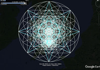
On realising it was possible to draw patterns on Google Earth, a deeper exploration of these ideas began.
Geometry
At some point, the love of maps and an emerging obsession with geometry joined forces and I found myself falling deep into an experiment with overlaying repeating geometric patterns onto Google Earth.
Partly driven by the challenge of creating perfect geometric patterns freehand onto a curved surface, which I just found to be completely addictive, and partly inspired by the incredibly satisfying way in which the patterns I was drawing phased in and out of alignment with the features on the map - I created endless versions of these drawings on the Earth.
The way that lines followed roads and curves hugged the landscape seemed to accentuate what was already on the map, as though everything on Earth could be conforming to these unseen geometries.
Alignments and co-incidences piled up until I began to believe it.
Strange dreams and visions suggested concepts I'd never considered. Some of them came true...
Then just as quickly, the whole thing would fall apart, and the realisation of what a ridiculous notion this all was brought me crashing back down to Earth as I slammed my laptop shut in bewilderment.
But the patterns kept drawing me back, whispering secrets from the landscape and inviting further enquiry.
It is out of this experimentation and exploration that OtherSide Maps has emerged.
What began as a creative investigation has developed into a fascinating and surprising project far beyond my original expectations or notions.
Quest
Something is going on with the Map.
Something’s not right.
Something’s been lost, forgotten, obscured by our incessant meddling and the ravages of violent Histories.
One doesn’t need to know what it is that one is searching for in order to begin the quest.
We just start.
Take off.
Head away from the well worn paths and beaten tracks into the unknown, with nothing to guide us but the maps we make ourselves.
Who knows what will be found when we go down that alleyway, or forest path we never noticed before? Or turn left, instead of right? When we take a leap through the invisible portal? Or keep going straight ahead when the signs say 'NO ENTRY'?
Who knows who, or what, we might meet in the un-chartered territories we missed when we walked with our heads down looking at our feet? When we overlooked the Old Ways for more convenient routes.
Perhaps we've blinded ourselves to the Real with our representative symbols and Two dimensional approximations; with our increasingly fast habits and distracted minds.
Maybe it's time to look more closely at the things right in front of our eyes, that we are failing to see.
Looking down on Earth from above, it seems obvious that we've lost our way, and no amount of GPS can save us from our detachment.
The Map is a mess - and so are we.
They say ‘The Map is not the territory’ - But maybe it should be?


